Drain Mapping in Yorkshire: What It Is, When You Need It & What the Survey Shows
Need drain mapping in Yorkshire? Learn what a drainage map shows, when you need one for building work, extensions, homebuying or insurance, and how CCTV tracing works.
If you are planning building work, buying a property, dealing with a drainage problem or trying to understand where your pipes actually run, a drain mapping survey can save a lot of guesswork.
Many Yorkshire properties have old, altered or poorly documented drainage. Extensions, shared drains, old clay pipework, combined sewers, converted cellars and previous building work can all make it hard to know what is underground.
A drain mapping survey gives you a clear layout of the system, so you can make decisions based on evidence — not assumptions. This guide explains what drain mapping is, when you need it, and what you receive afterwards.
What is drain mapping?
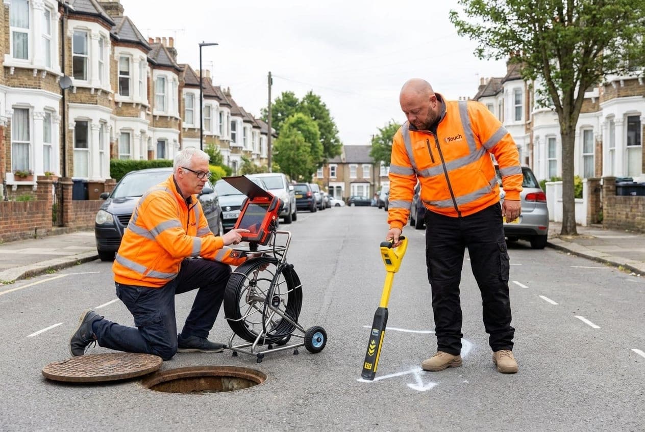
Drain mapping is the process of locating, tracing and recording the route of underground drainage pipes.
A drainage engineer uses specialist CCTV cameras, sonde tracing equipment and access chambers to follow the pipework from one point to another. The aim is to identify where the drains run, which direction they flow, where inspection chambers sit, and whether any defects are present.
A drainage map may show:
- The route of foul water drains
- The route of surface water drains
- Inspection chambers and manholes
- Pipe direction and approximate pipe depth
- Connections between different runs
- Shared drainage arrangements
- Pipe defects, blockages or collapsed sections
- Pipe material, where visible
- Areas that may need further investigation
For homeowners, builders, architects and buyers, this information is invaluable before any money is committed to building work or a property purchase. It's also worth understanding what a CCTV drain survey shows in its own right.
When do you need a drain mapping survey?
You may need drain mapping if you don't know where the drainage runs, or if you need evidence for another party — a builder, architect, insurer, solicitor, surveyor or water company.
Common reasons include:
- Planning a home extension
- Building near or over a sewer
- Buying a property
- Investigating repeat blockages
- Preparing for excavation or groundworks
- Checking whether a drain is shared
- Supporting an insurance claim
- Finding an unknown or hidden manhole
- Tracing rainwater drainage from roofs, drives or patios
- Checking whether surface water connects to a soakaway or sewer
In older towns and cities such as York, Wakefield, Leeds and Bradford, drainage layouts are not always obvious. Properties may have been extended several times, chambers may have been covered over, and older pipe runs may not follow the route you'd expect.
Drain mapping before a home extension
One of the most common reasons to book drain mapping is before building an extension.
If your proposed extension is close to an existing sewer or drain, you need to know where that pipe actually runs. Building over the wrong area can create serious problems later, and an unclear layout can delay building control approval.
A drain mapping survey helps you understand:
- Whether drains pass beneath the proposed extension footprint
- Whether a public sewer or shared drain may be affected
- Whether existing manholes need to be moved or protected
- Whether any pipework is already damaged before work starts
- Whether a build-over agreement or further permission may be needed
It is far cheaper to find a drainage issue at planning stage than after foundations have been dug. If you're building over or near a public sewer, read our guide to what a build-over survey is.
Drain mapping when buying a house
A standard homebuyer survey doesn't normally include a CCTV inspection of the drains. That means buyers can reach exchange without knowing whether a property has damaged pipework, root ingress, collapsed drains, hidden manholes or drainage running beneath future extension areas.
Drain mapping is particularly useful when buying:
- Older terraced houses
- Properties with extensions
- Homes with cellars or basements
- Properties with large gardens
- Houses with trees close to the drainage route
- Homes with shared access or shared drainage
- Properties showing damp, subsidence or drainage smells
The value is simple: you know what you're buying before you commit. If defects are found, you can discuss them with your solicitor or the seller before exchange.
Drain mapping for insurance claims
If there has been flooding, sewage backup, subsidence, damp ingress or suspected pipe damage, your insurer or loss adjuster may ask for drainage evidence.
A drain mapping survey can show:
- Where the affected drain runs
- Whether the pipe is private, shared or likely to connect to a public sewer
- The location of the defect
- Whether the issue is caused by root ingress, displacement, fracture, collapse or blockage
- Whether further repair work is required
This is far stronger than a verbal opinion. A proper CCTV report and drainage plan gives insurers something they can assess.
Drain mapping for repeat blocked drains
If a drain keeps blocking after jetting, there is usually a reason. The blockage may clear temporarily, but the underlying fault remains.
Drain mapping and CCTV inspection can identify causes such as:
- Root ingress
- Bellied pipework holding water and waste
- Collapsed clay pipe
- Displaced joints
- Scale build-up
- Poor fall or backfall
- Misconnected pipework
- Shared drain surcharge from another property
For repeat blockages, mapping pinpoints the exact section causing the issue — so the repair can be targeted rather than guessed.
What happens during a drain mapping survey?
A typical survey follows a clear process:
- The engineer locates available access points — manholes, rodding eyes, gullies or inspection chambers.
- A CCTV camera is inserted into the drain and used to inspect the pipe internally.
- Where needed, tracing equipment locates the camera head from above ground to confirm the route and mark key points on the surface.
- The engineer builds a practical drainage layout based on the inspected runs.
Depending on the property, the engineer may also check roof drainage, surface water connections, shared drains and unknown chambers.
What does the drainage map include?
The exact format depends on the site and purpose, but a drain mapping report normally includes:
- A written summary of the drainage layout
- A plan or sketch showing inspected runs
- CCTV footage or still images where relevant
- Notes on pipe condition
- Defect locations
- Flow direction
- Recommendations for repair or further investigation
If the survey is for building work, insurance or conveyancing, tell us before the appointment so the report can be prepared with that purpose in mind.
Can every drain be mapped?
Most systems can be mapped, but there are limits. A camera cannot pass through a fully collapsed section, a severe blockage or an inaccessible pipe. Access may also be restricted by covered manholes, buried chambers, decking, extensions or concrete.
If an area cannot be inspected, the report makes this clear and explains the next step — clearing a blockage, lifting a covered chamber, dye testing or a targeted excavation.
The key point is that the survey removes uncertainty. Even when a full map isn't possible on the first visit, you still come away knowing what is accessible, what is not, and what needs to happen next.
Drain mapping in York, Wakefield and across Yorkshire
Drain mapping is especially useful in Yorkshire because of the variety of property types and ground conditions. Historic areas such as York often have complex layouts and pipe runs altered over generations. Wakefield, Barnsley, Doncaster and other former mining areas can also have older infrastructure and ground-movement considerations.
Across Leeds, Bradford, Huddersfield, Sheffield, Harrogate, Beverley and Hull, we regularly find layouts that differ from what homeowners expected. A CCTV drain mapping survey gives you the facts before you build, buy, repair or claim.
Frequently Asked Questions
How is drain mapping different from a standard CCTV survey?
A CCTV survey inspects the condition inside the pipe; drain mapping adds above-ground tracing to record the route, depth and connections, producing a layout plan of the whole system.
How long does a drain mapping survey take?
Most residential surveys take a couple of hours, depending on the number of runs, the access available and the size of the property. We confirm a fixed quote before we attend.
Will I get a drainage plan I can give to my builder or solicitor?
Yes. The report includes a plan or sketch of the inspected runs along with notes and footage, prepared for the purpose you tell us about — building work, conveyancing or an insurance claim.
Book a drain mapping survey in Yorkshire
If you need to know where your drains run, Yorkshire Drain Survey can help. We provide CCTV drain surveys, drain tracing and practical drainage reports for homeowners, buyers, landlords, builders and businesses across Yorkshire.
Call 0113 734 2245 for a quote, or fill in our contact form and we'll get back to you the same day.
Related guides
Blocked Drain Keeps Coming Back? Why Jetting May Not Fix the Real Problem
If your blocked drain keeps returning after jetting, there may be a deeper fault. Learn the common causes and when to book a CCTV drain survey in Yorkshire.
Read guide →The Importance of Regular Drain Maintenance in Yorkshire
Why regular drain maintenance matters for Yorkshire homes — how it prevents blockages, the warning signs to watch for, and how often to book a CCTV inspection.
Read guide →Drain Maintenance in Yorkshire: Why It's Crucial for Homeowners
Why regular drain maintenance matters for Yorkshire homeowners, and how a CCTV survey catches problems early and saves you from costly repairs.
Read guide →Get in touch
Need a CCTV drain survey in Yorkshire?
Same-day available. Full written report. Transparent pricing. Call us or fill in the form.